Belfast Harbor Maine Tide & Weather - Jul 16, 2026. Sunrise: 05:05 - Sunset: 20:18 |
BatV: 4.192 rssi: -70.0 |
|
|
|||||||
|
Weather data provided by OpenWeather |
Air Temp |
humidity |
Dew Point |
Winds |
Gusts |
Barometer |
Rain Rate |
Rain Today |
||
Jul 16, 2026 12:50 |
76° F |
70% |
65° F |
W 3 mph |
13 mph |
29.65 |
|
|
||
|
NDBC - Station 44007 (LLNR75) - (43.525N 70.140W) - 12NM Southeast of Portland |
||||||||||
Offshore Conditions |
Air Temp |
Wave Hgt |
Wave Per |
Winds |
Gusts |
Barometer |
Water Temp |
Wave Dir |
||
Jul 16, 2026 12:10 |
65.5° F |
1.6 ft |
9 secs |
SW 15.6 kts |
19.4 kts |
29.68 |
60.3° F |
SE |
||
Belfast Harbor Maine Five Day Weather Forecast |
||||||||||
| This Afternoon | Tonight | Friday | Friday Night | Saturday | Saturday Night | Sunday | Sunday Night | Monday | Monday Night | |
| High: 79°F | Low: 57°F | High: 78°F | Low: 57°F | High: 77°F | Low: 60°F | High: 78°F | Low: 57°F | High: 80°F | Low: 58°F | |
| W 10 to 15 mph | NW 5 to 10 mph | NW 10 mph | W 0 to 10 mph | SW 0 to 10 mph | S 5 to 10 mph | W 5 to 10 mph | NW 5 to 10 mph | W 5 to 10 mph | S 0 to 5 mph | |
|
|
|
|
|
|
|
|
|
|
| |
| Showers And Thunderstorms Likely | Mostly Clear | Sunny | Partly Cloudy | Partly Sunny then Chance Showers And Thunderstorms | Showers And Thunderstorms | Chance Rain Showers then Mostly Sunny | Mostly Clear | Sunny | Partly Cloudy | |
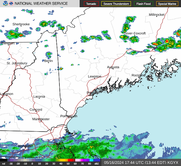
Detailed Forecast This Afternoon: A chance of rain showers between 1pm and 2pm, then showers and thunderstorms likely. Some of the storms could be severe. Partly sunny. High near 79, with temperatures falling to around 73 in the afternoon. West wind 10 to 15 mph, with gusts as high as 25 mph. Chance of precipitation is 70%. New rainfall amounts less than a tenth of an inch possible. Tonight: Mostly clear, with a low around 57. Northwest wind 5 to 10 mph. New rainfall amounts less than a tenth of an inch possible. Friday: Sunny, with a high near 78. Northwest wind around 10 mph, with gusts as high as 25 mph. Friday Night: Partly cloudy, with a low around 57. West wind 0 to 10 mph. Saturday: A chance of rain showers between 1pm and 5pm, then a chance of showers and thunderstorms. Partly sunny, with a high near 77. Southwest wind 0 to 10 mph. Chance of precipitation is 40%. Saturday Night: Showers and thunderstorms. Cloudy, with a low around 60. Chance of precipitation is 90%. Sunday: A chance of rain showers before 11am. Mostly sunny, with a high near 78. Chance of precipitation is 50%. Sunday Night: Mostly clear, with a low around 57. Monday: Sunny, with a high near 80. Monday Night: Partly cloudy, with a low around 58. |
|
| Hourly Marine Point Forecast - 12nm SE of Portland Maine - Location: 43.525 -70.14 | ||||||||||
|---|---|---|---|---|---|---|---|---|---|---|
| Time | 12:00PM | 01:00PM | 02:00PM | 03:00PM | 04:00PM | 05:00PM | 06:00PM | 07:00PM | 08:00PM | 09:00PM |
| Temperature | 68° F | 69° F | 69° F | 68° F | 67° F | 67° F | 66° F | 66° F | 65° F | 66° F |
| Wind Speed | WSW 11kt | WSW 11kt | SW 12kt | WSW 11kt | W 9kt | W 8kt | W 8kt | W 7kt | W 7kt | W 6kt |
| Wind Gust | 20kt | 20kt | 22kt | 20kt | 17kt | 15kt | 15kt | 14kt | 14kt | 12kt |
| Wave Ht. | 0ft | 0ft | 0ft | 0ft | 0ft | 0ft | 0ft | 0ft | 0ft | 0ft |
| Weather | slight chance light rain showers | patchy smoke | chance heavy thunderstorms chance light rain showers slight chance heavy thunderstorms patchy smoke | likely heavy thunderstorms likely light rain showers slight chance heavy thunderstorms patchy smoke | likely heavy thunderstorms likely light rain showers slight chance heavy thunderstorms | chance heavy thunderstorms chance light rain showers | slight chance light rain showers | |||